Guidelines for drone mapping
Key Findings
After reading this article, a number of conclusions can be made:
1. Relative and absolute accuracy.
2. Necessity and non-necessity of GCPs.
3. Obtaining contour lines
Ground Control Points for Drone Mapping
1. Obtaining Contour lines by using accurate GCPs
Accurate GCPs must be provided to the photogrammetric softwares to obtain high quality georeferencing.
The steps to be followed are:
1.1 Using visible and vast targets
GCP targets are typically marked as a large X on the ground or a concentric circle with a center point. Contrasting colors such as black and white make the markings easily visible from higher altitudes.

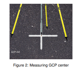
1.2 Measurement of GCP center using accurate Global Positioning System
High quality Global Positioning System is required for creating accurate GCPs. There is a requirement for Real Time Kinematic(RTK) GPS receiver or Post Processing Kinematic(PPK) GPS receiver.

1.3 Distribution of GCPs uniformly throughout the map
Distribute the map with a minimum of 4 GCPs. It is preferable using 5 GCPs locating 4 at each corner of the map and the center. An offset of 50 feet buffer from the GCPs to the boundaries of the map must be maintained.

1.4 The GCPs should be unimpeded and properly seen
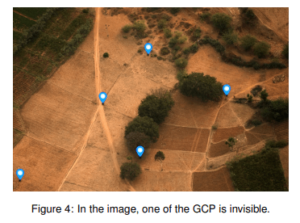
The markers must be clearly seen while processing with any flight altitude for creating accurate GCPs. Visual impedances like snow, fog ,flare or shades would make difficult to identify the GCPs in the images.

2. Relative and Absolute accuracy
2.1 Relative accuracy
Relative accuracy can be defined as:
“The degree to which the distances between points on a map correspond to the actually distances
between those points in the real world.”
To have high relative accuracy it does not matter where the map is located as long as it’s size and shape are correct.
• High relative accuracy is obtained without GCPs.
• Relative accuracy is considered while measuring the length, area and volume of the mapped area. It is important for correct spacing of contour lines in an aerial topographical survey

2.2 Absolute accuracy
Absolute accuracy can be defined as:
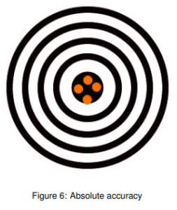
“The degree to which the measured position of a point on a map corresponds to its actual position in the real world.”
To have high absolute accuracy a map must have the correct size, shape, and location when compared with the real world.
• High absolute accuracy is obtained with GCPs.
• Absolute accuracy is considered when there is a requirement for geo-referenced design documents for construction project or conducting property boundary surveys. It is also critical for measuring correct elevation values for contour lines.

3. When GCPs are required
3.1 Necessity of GCPs
GCPs are required if absolute accuracy is important. Drone mapping projects that require high absolute accuracy include:
• Land Title Surveys
• As-Built Surveys
• Environmental Documentation
• Overlaying Geo-Referenced Site Plans
3.2 Non necessity of GCPs
GCPs are not required if only relative accuracy is important. Drone mapping projects that only require high relative accuracy include:
• Measuring length, area, and volume of objects
• Construction Site Management and Oversight
• Crop Scouting
