
Topographical survey and volumetric calculations of open PIT mine by TAS mapper series UAS
Overview
Using TAS Mapper Series Unmanned Aerial Systems to do topographical survey , measurements and
extraction of volume in an open pit mine.
Objectives
1. Topographic surveys of quarries
2. Elevation and volumetric calculation.
3. Measurement of roads and other features extraction.
Deliverables
1. High resolution orthomosaic.
2. Point cloud data in LAS format.
3. Stockpile volume calculations.
4. Detailed topographic survey in AutoCAD /ArcGIS formats.
5. Detailed contour model in dbf formats.
6. 3D model in Illustrator pdf formats.
Case study: Topographical Survey and Volumetric Calculations of Open pit mine by TAS Mapper Series
UAS
1. Quarry volume extraction by using TAS mapper series of UAS
Quarries are areas of high risk and hence take a lot of human effort to measure volume. Quarry owners can use UAS to monitor features of their quarry and measure parameters such as area, volume, etc. Bird take close-up images of the quarry surface. Aerial data can be used to render orthomosaic image. With the help of an orthomosaic image, volume extraction can be measured. Customers can easily measure the parameters without visiting the quarry.
1.1 Project Workflow

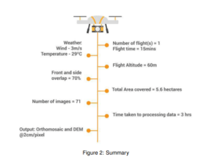
2. Flight Parameters

3. Processed image and comparisons


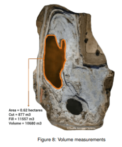
4. Parameters measurements
With the help of processed data, we measured the volumetric of stagnated water and width of the access
road and haul road.

5. Creating Orthomosaic image and Digital Elevation Model (DEM)
We created Orthomosaic and DEM with the help of Geo-tagged images. This helped to visualize details about the mapped area.

Results
1. Faster turn around.
2. Increased accuracies.
3. Increased safety.